
Adrien Perkins
Co-Founder & VP of Engineering

A year ago today, Xona’s team watched Pulsar-0 launch into Low Earth Orbit aboard a SpaceX Falcon 9 rideshare mission.
For many of us, that moment represented years of work compressed into a single mission, bringing early benchtop prototypes, ground-based demonstrations, hosted mission, simulations, and design reviews through to a customer-facing signal for the first time.
Since then, our engineering and mission teams have worked tirelessly with our industry partners and customers to test and validate the promise of Pulsar in the field. In its first year on orbit, Pulsar-0 has supported:
350+ transmission passes across four continents
22TB of GNSS observability data from on-orbit sensors
Independently tracking across more than a dozen commercial receivers
Four major on-orbit software updates
Live-sky customer and partner demonstrations around the world
When we launched Pulsar-0, our mission was to demonstrate a meaningful improvement to the status quo through new features and native capabilities the market had never seen before. One year later, we’ve delivered on this goal.
A software-defined signal that keeps improving
Historically, satellite navigation has progressed slowly. Signals, standards, and infrastructure typically evolve alongside hardware refresh cycles that take decades to actualize. That model made sense when GPS was first launched in the late 1970s, but it is not built for a world where threats, devices, and user needs are changing rapidly.
One of the most important choices we made in Pulsar’s architecture was building around a software-defined payload. That has allowed us to learn from real users in the field, then turn those lessons into on-orbit improvements. Over the past year, we have deployed four major software updates to Pulsar-0, each adding new capability and improving robustness.
Built-in protection
The need for resilient navigation has become more obvious over the past year.
Today’s GPS signals are low-power and unauthenticated, which creates an opening for malicious actors to either overpower them with noise or generate counterfeit signals that receivers may perceive as real. Amid ongoing conflicts in Europe and the Middle East, GPS jamming and spoofing have increasingly disrupted civilian applications across aviation, logistics, agriculture, and other critical sectors.
Against this backdrop, Pulsar-0 has tested a different model built for resilience in contested environments, not just under ideal conditions.
In live-sky jamming tests across multiple countries, we have shown Pulsar reception under intense radiofrequency interference where GPS was unavailable. Those tests have helped validate that Pulsar’s 100x stronger signals, forward error correction, and other signal design advancements can reduce a jammer’s effective area by 95%.

Pulsar-0 has also advanced the state of the art in GNSS spoofing resistance to protect global shipping and aviation traffic against spoofing - intentional attacks designed to confuse onboard navigation and collision avoidance systems.
Pulsar broadcasts include an anti-spoof watermark enabling receivers to utilize cryptographic proofs to determine the signal came from satellites in orbit, not adversaries on the ground. With our latest software update, this protection is built-in to every broadcast – making the first zero-trust ranging authentication service ready for deployment the moment our commercial service begins.
A new standard in native performance
Pulsar-0 has also validated the performance characteristics we set out to prove from the beginning: stronger reception, greater compatibility, and native precision delivered directly from orbit.
Indoor penetration
In indoor reception testing, Pulsar has been acquired, tracked, and generated timing outputs within the concrete confines of our Montréal office, extending signal reception in places where the 100x weaker signals of GPS can’t reach.

Native precision
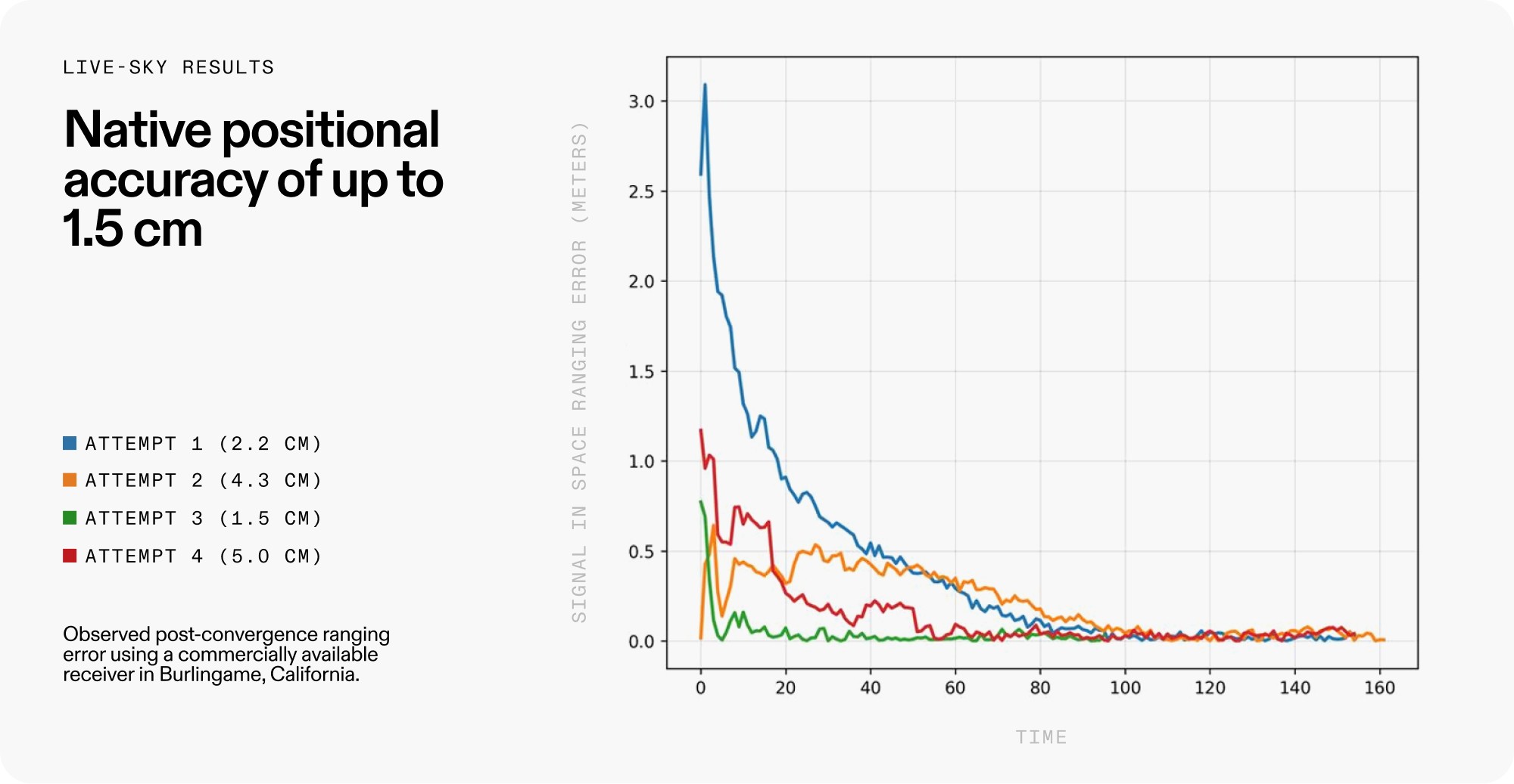
High-accuracy positioning today typically depends on layers added around GNSS, including correction streams, monitoring networks, convergence time, and reliable data delivery. Pulsar takes a different approach by moving complexity into the satellites themselves through stronger signals, faster LEO geometry, and onboard estimation.
Over the past year, on-orbit software updates have improved Pulsar-0’s native positioning accuracy by more than 2.8x. After first achieving 4.2 cm ranging error last fall, our latest updates pushed Pulsar-0 to a new best result of 1.5 cm native accuracy, bringing centimeter-level performance directly from orbit.
Compatibility
We developed a system to fit within a challenging intersection: a world with billions of devices using signals in a spectrum everyone said was impossible to access. Today, Pulsar has been tracked in receivers built by over a dozen different vendors, spanning a global demo footprint from the high latitudes of Finland to the southern skies in Australia.
We’ve shown it is possible to artfully craft a signal that can coexist with existing GNSS signals in the very same spectrum band – all while delivering performance beyond what others had been providing natively: 100x more power, authentication from the ground up, centimeter-level precision out of the box.
The next chapter
Pulsar-0 still has its moments of fanfare as we expand features, incorporate lessons learned, and mature our operations. But more than anything, it has pulled us deeper into the realities of running a production service.
At its core, this mission was to prove Pulsar can deliver our service to users end-to-end. That meant demonstrating the signal, working with customers on real hardware, testing new features in the field, and building the operational muscle required to run a navigation service from space.
Meanwhile, the need for a stronger foundation for positioning, navigation, and timing has never been clearer. GPS jamming is affecting wide regions around conflict zones, with consequences for civilian aviation, shipping, agriculture, and daily life. New threats are emerging. At the same time, the physical world is becoming more connected, autonomous, and location-aware.
In a year, Xona has moved from proving LEO PNT is the inevitable next evolution to GNSS to now scaling the manufacturing and operational muscle to enable global service. With our dedicated spacecraft manufacturing facility now open and growing investments in vertical integration, the challenge ahead is to build and deploy our 250+ satellite constellation that will power the future of technology everywhere on Earth.
The mission now is scale.

